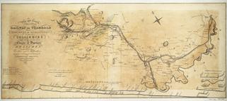
Coloured map. Wilson's New Map of Northumberland
- Made:
- 1865 in Newcastle upon Tyne
Coloured map. Wilson's New Map of Northumberland, with parts of Durham, showing the Collieries & Ttramways, also all the Railways and Stations, with the Proposed New Lines of Railway. (c1865). Published by D H Wilson, Grey Street, Newcastle-upon-Tyne. Backed on linen. Part loss near bottom right-hand corner.
Details
- Category:
- Railway Maps & Plans
- Object Number:
- 1996-7919
- Measurements:
-
overall: 107.5 x 26.5 cm
- type:
- map of northumberland
- credit:
- Snowball, Worthy & Lowe