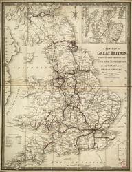
Scarborough's map of the British Isles
- Made:
- 1911-1914
![]() This image is released under a CC BY-NC-SA 4.0 Licence
This image is released under a CC BY-NC-SA 4.0 Licence
Buy this image as a print
BuyLicense this image for commercial use at Science and Society Picture Library
License
Science Museum Group Collection
© The Board of Trustees of the Science Museum
Coloured map (double-sided). Scarborough's Map of the British Isles comprising Scarborough's New Map of England and Wales and Scarborough's New Map of Scotland and Ireland. (c1914). Includes provinces, counties and boroughs, and all railways and steamship lines with distances between stations and landings; with inset maps, indexes of places and various information including detailsfrom the 1911 census. copyright, 1911 and 1914, by The Scarborough Co, Indianapolis, Ind, USA. Published by The Scarborough Company , Balfour House, Finsbury Pavement, London, EC. Printed by The Scarborough Company, Boston, USA. Folded with slip case. 976 x 1071 mm (flat). 130 x 298 (folded).
Details
- Category:
- Railway Maps & Plans
- Object Number:
- 1997-7150
- Measurements:
-
: 976 x 1071 mm
- type:
- coloured map
- credit:
- Johnson, John