
Map poster for the Cinerama film, 'How the West Was Won'
- Made:
- 1962 in unknown place
![]() This image is released under a CC BY-NC-ND 4.0 Licence
This image is released under a CC BY-NC-ND 4.0 Licence
Buy this image as a print
BuyLicense this image for commercial use at Science and Society Picture Library
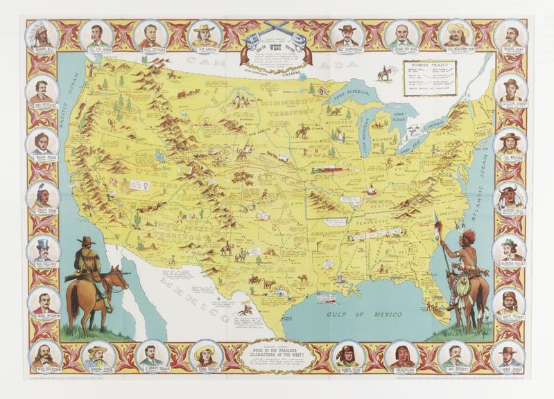
LicenseMap poster produced for advertising purposes for the film 'How
Science Museum Group
© The Board of Trustees of the Science Museum, London
Map poster produced for advertising purposes for the film 'How the West Was Won', 1962, illustrating the 'history of the American Indian', from 1840 to about 1900.
While styled as a Native American map and displaying the territorial borders of the United States prior to the formation of Nebraska Territory in 1854, the present map is more of a history of Native Americans, famous Americans and the west. The map is ringed with portraits of famous Native Americans and important figures from the American West. The historical vignettes range from the location and dates of the discovery of gold in several parts of the west, to the location of John Brown's hanging in 1859, to Lincoln's inaugural speech in 1861 and to Robert Fulton's construction of the first steamship. The majority of the historical vignettes provide dozens of interesting western history facts and the location of important overland routes. Danny Arnold is likely Daniel Alvin Arnold, one of the directors of the Old Western Trading Company of London.
Details
- Category:
- Cinematography
- Object Number:
- 2019-291
- Materials:
- paper (fibre product)
- type:
- poster
- credit:
- Mr E Dodsworth


