
![]() This image is released under a CC BY-NC-SA 4.0 Licence
This image is released under a CC BY-NC-SA 4.0 Licence
Buy this image as a print
BuyLicense this image for commercial use at Science and Society Picture Library
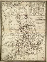
LicenseSmith’s Railway Map, 1836
Science Museum Group Collection
© The Board of Trustees of the Science Museum
'Smith's Railway Map', 1836, by Charles Smith & Son. Shows network of lines in England. Printed and hand coloured.
Details
- Category:
- Railway Maps & Plans
- Object Number:
- 1998-75
- Measurements:
-
overall: 450 cm x 360 cm
- type:
- map
- credit:
- Unknown source