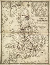
Betts's New Itinerant and Commercial Map of England & Wales, on which the various Lines of Railroad, the turnpike & principal cross roads, with the courses of the rivers & canals, are carefully laid down, and the situations of the cities, market towns and principal villages, accurately & clearly described / John Betts (publisher, 7 Compton St., Brunswick Sq., London). 1840. 1 col. engr. sheet folded in box. Scale 2 1/2" : 3m. Box bears title 'Betts's England & Wales with the Railroads &c'. Part of the John Phillimore collection, cat. 1, 1840, page 9. Bears name of Henry Geldart (first owner?)]
Details
- Category:
- Railway Maps & Plans
- Object Number:
- 2002-100
- type:
- map
- credit:
- Sotheby and Company